Chronicles of Mhoriedh Map 00 Olden Lands Continent
 |
ABOUT THIS PRODUCT
There are seven maps included with this product¸ each of the same area and detailing different aspects of the Olden Lands. This is "Map 00¸" the baseline continental map for the Chronicles of Mhoriedh campaign setting. They are designed for use with the forthcoming Gazetteer of the Olden Lands; they are presented for sale here separately for those who would simply like to have the maps.
MAP 00: MAP SCALE
The official scale on Map 00 is 75 miles per hex¸ with the map being 30 hexes north to south and 50 hexes east to west. The map is about 2¸400 miles north to south and about 3¸400 miles east to west¸ for a total area of 8¸160¸000 square miles.
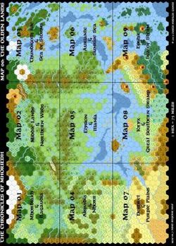
The Continental map will be divided into nine Regional maps. The Regional maps will also have 30 hexes north to south and 50 hexes east to west¸ and be at a scale of 25 miles per hex.
Each Region can then be broken down into 25 Area maps¸ each at 5 miles per hex. But I have no plans on doing that¸ as that would entail creating 225 maps! But we might call out some Areas now and again with special maps¸ as opportunity permits.
We will support specific Hexes with further detail¸ using the 25HEX system breaking down each 25 mile hex into 25 5-mile hexes¸ and subsequently showcasing the area by further breaking the core 19 5-mile hexes of each 25-mile hex down on a map 25 hexes across at a scale of 1/5th of a mile per hex.
If you wish¸ you can also set the scale at 72 miles per hex on the Continental map¸ which would give you a scale of 24 miles per hex on the Regional maps. This would then give you a scale of 8 miles per hex on nine Area maps per Region.
You could also go with a scale of 90 miles per hex on the Continental map¸ which would give you a scale of 30 miles per hex on the Regional map¸ and 10 miles per hex on nine Area maps per region.
You are hereby authorized to print any of the maps included with this product for personal use only. Please do not sell¸ share¸ or give these maps away¸ either in electronic or print form¸ except as excerpts as needed for your personal campaigns.
MAP 00_1: GEOGRAPHICAL PLAIN
This map provides you with the plain geographical and topographical lay of the land. It should be noted that at the 90 mile per hex scale¸ the indicated feature is simply the majority geographical feature¸ not necessarily overwhelming all other features in the area. A 90-mile hex has 81 10-mile hexes within its environs; that's a lot of territory!
MAP 00_2: GEOGRAPHICAL NAMES
This map provides you with the names of the major geographical and topographical features of the Olden Lands. Not every range of hills or river is named¸ but most of the important ones are¸ as are all areas mentioned in this product.
MAP 00_3: REGION NAMES
This map breaks the Olden Lands into its major constituent parts. Some of these areas are kingdoms¸ and some are empires¸ while others are cultural regions or simple geographic areas¸ depending on the nature of the civilization prevalent in the region. Those areas shown that are kingdoms are depicted with their "best hoped borders" presented; while claims might be quite grandiose¸ in many cases such borders are honored more in the breach than in any other fashion. Consult the entries in this volume for more information on each realm and region.
MAP 00_4: SETTLEMENT NAMES
This map shows the location of major settlements. What is a major settlement in one region might well be a rustic hamlet in another. Settlements that are noted with a white star in a red circle are capitals for their respective kingdoms or racial realms¸ with the exception of Velantia¸ which is a major free city (and the largest city in the Olden Lands). The